Geotechnical Engineering: Soil and Foundation Analysis
Site Investigation & Soil Profiling
Site Investigation & Soil Profiling
Site Investigation & Soil Profiling
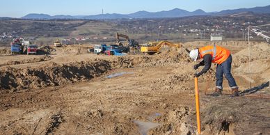
Includes borehole drilling, cone penetration testing (CPT), standard penetration testing (SPT), and geophysical surveys to characterize subsurface conditions.
Laboratory Testing
Site Investigation & Soil Profiling
Site Investigation & Soil Profiling

Soil classification (Atterberg limits, grain size analysis), strength testing (triaxial shear, unconfined compression), and consolidation tests.
Foundation Design
Site Investigation & Soil Profiling
Slope Stability Analysis
Shallow foundations (spread footings, mat foundations) and deep foundations (piles, caissons) designed based on bearing capacity, settlement analysis, and lateral load resistance.
Slope Stability Analysis
Earth Retaining Structures
Slope Stability Analysis
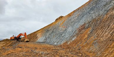
Use of limit equilibrium methods and finite element modelling to assess natural and engineered slopes.
Earth Retaining Structures
Earth Retaining Structures
Earth Retaining Structures
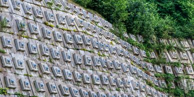
Design of retaining walls, sheet piles, and mechanically stabilized earth (MSE) walls using state of the art latest geotechnical software applications.
Ground Improvement
Earth Retaining Structures
Earth Retaining Structures
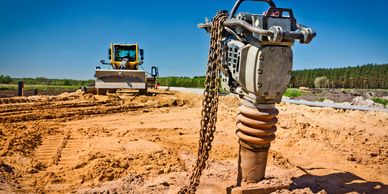
Includes vibro-compaction, jet grouting, soil stabilization, and geosynthetics for enhancing soil properties.
Detailed Survey and 3D Laser Scanning
Topographic Surveys
Digital Terrain/Elevation Models
Topographic Surveys

Use of tools such as GNSS (Global Navigation Satellite System), total stations, and drones to map terrain features and elevation contours.
3D Laser Scanning
Digital Terrain/Elevation Models
Topographic Surveys
Captures data points (point clouds) to create precise 3D models of existing structures, terrain, and infrastructure using tools such as LiDAR.
Digital Terrain/Elevation Models
Digital Terrain/Elevation Models
Digital Terrain/Elevation Models
Generated from scan data for hydrological modeling, earthworks planning, and visualisation.
BIM Integration
Underground Utility Mapping
Digital Terrain/Elevation Models
Point cloud data is converted into Building Information Models (BIM) for clash detection, design validation, and construction sequencing.
Deformation Monitoring
Underground Utility Mapping
Underground Utility Mapping
High-precision repeat surveys to detect structural or ground movement over time.
Underground Utility Mapping
Underground Utility Mapping
Underground Utility Mapping
Use of tools such as Ground Penetrating Radar (GPR) and electromagnetic locators to identify buried services.
Structural Engineering, Design and Drawing
Load Analysis
Structural Modeling & Simulation
Structural Modeling & Simulation
Includes dead loads, live loads, wind, seismic, thermal, and dynamic loads using standards like ASCE 7, Eurocode, or AS/NZS.
Structural Modeling & Simulation
Structural Modeling & Simulation
Structural Modeling & Simulation
Finite Element Analysis (FEA) using software like ETABS, SAP2000, STAAD.Pro, ANSYS, etc.
Material Design
Structural Modeling & Simulation
Foundation System
Steel, reinforced concrete, prestressed concrete, timber, and composite structures designed per relevant codes.
Foundation System
Structural Health Monitoring
Foundation System
Integration with geotechnical data to design pile caps, raft foundations, and grade beams.
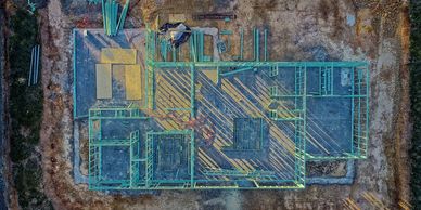
Detailing & Drafting
Structural Health Monitoring
Structural Health Monitoring
Production of construction drawings (GA, reinforcement details, connection details) using AutoCAD, Revit, and Tekla Structures.
Structural Health Monitoring
Structural Health Monitoring
Structural Health Monitoring
Deployment of sensors and data acquisition systems to monitor stress, strain, vibration, and displacement in real-time.
Power Plant Engineering: Civil Design and Integration
Site Development
Foundation for Heavy Equipment
Foundation for Heavy Equipment
Grading, drainage, access roads, and stormwater management tailored to plant layout and environmental constraints.
Foundation for Heavy Equipment
Foundation for Heavy Equipment
Foundation for Heavy Equipment
Specialised foundations for turbines, generators, boilers, and cooling towers considering dynamic loads and vibration isolation.
Structural Design
Foundation for Heavy Equipment
Hydraulic Structures
Buildings (control rooms, switchyards, substations), pipe racks, cable trenches, and cooling water systems.
Hydraulic Structures
Integration with MEP Systems
Hydraulic Structures
Design of intake/outfall structures, canals, and reservoirs for hydro and thermal plants.
Seismic & Blast Resistance
Integration with MEP Systems
Integration with MEP Systems
Design for resilience against seismic events and accidental explosions using advanced simulation tools.
Integration with MEP Systems
Integration with MEP Systems
Integration with MEP Systems
Coordination with mechanical, electrical, and piping systems for efficient layout and constructability.
Major and Complex Infrastructure Engineering
Transport Infrastructure
Urban Utilities & Services
Transport Infrastructure
Design of highways, expressways, interchanges, tunnels, and rail systems using tools like Civil 3D, MX Road, and OpenRoads.
Bridge Engineering
Urban Utilities & Services
Transport Infrastructure
Includes cable-stayed, suspension, arch, and box girder bridges with detailed analysis of load paths, fatigue, and long-term durability.
Urban Utilities & Services
Urban Utilities & Services
Project Phasing & Logistics
Planning and design of water supply, sewerage, stormwater, electrical, and communication networks.
Project Phasing & Logistics
Environmental & Sustainability
Project Phasing & Logistics
Construction sequencing, traffic management, and stakeholder coordination for minimal disruption
Environmental & Sustainability
Environmental & Sustainability
Environmental & Sustainability
Use of green infrastructure, low-impact development (LID), and carbon footprint analysis.
Smart Infrastructure
Environmental & Sustainability
Environmental & Sustainability
Integration of IoT sensors, digital twins, and real-time monitoring systems for asset management and predictive maintenance.